
 Support

Icebound Maps
TopoMap Real Estate Map (Subdued)
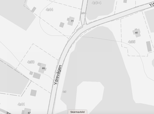
TopoMap Real Estate Map (Subdued)
A comprehensive, informative, and well-balanced property map at all zoom levels, presented in a muted color scheme. Based on our core product, TopoMap, it also includes building areas and property areas/boundaries with block designations at lower zoom levels. By clicking the info icon in WMS, you can also get more information about the property, such as the property designation, municipality, detail type, data currency, and more.
The map is organized as a single layer and is often used for activities where property boundaries and designations are important, such as hunting maps, forestry maps, and more.
TopoMap Cadastre is based on data from the GSD Property Map © Lantmäteriet and the Swedish Transport Administration (NVDB).
Click below for a demo!

Frequency of Updates: Updated 12 times a year
Delivery format:
- WMS 1.1.1/1.3.0 with GetFeatureInfo (info click) on property area. Pre-rendered (cached) in Sweref 99 TM and Web Mercator. Otherwise, direct rendering in various systems as specified in the documentation.
- WMTS 1.0.0 with GetFeatureInfo (click-to-view) on property boundaries. Pre-rendered (cached) in Sweref 99 TM and Web Mercator. Otherwise, direct rendering in various systems as specified in the documentation.
Icebound is an IT company that provides products and e-services that digitize our customers’ businesses and make them more sustainable. We specialize in Geographic Information Systems (GIS) and digital mapping.
Drawing on our many years of experience and our innovative team, we help customers in the basic industries—primarily the forestry sector—in Sweden and internationally to operate efficiently and make the right decisions.
Icebound is part of the Addnode Group (listed on Nasdaq Stockholm). For more information, visit: www.addnodegroup.com
Icebound AB has been certified under FR2000 since its founding in 2024. Read more!